iOS 4.8
Join Beta
iOS beta builds (TestFlight) are usually provided weekly (after a Team Sprint demo). They do not contain descriptions and may have continuous versioning. They are assumed to be stable and ready to use.
What's new
- New Speedometer widget compatible with CarPlay.
- Added Turn-by-turn instructions to the route details.
- The new Add action screen of the Quick Actions tool has been updated.
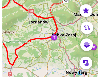
- Updated the ability to customize the map screen by adding multiple Quick Action buttons.
- Customize the map screen by adding multiple "Quick Action" buttons
- Improvements new visualization and coloring options for the 3D track view.
- Added improved multiselect mode for Tracks.
- 3D options for My location icons.
- Added features for working with custom Color palette files in this release.
- Weather UI has been updated with layer animations and improved label visibility.
- Added smooth transitions when zooming in 3D mode.
- Location position on screen setting has been moved to the Configure screen menu.
- The Route detail menu has been updated with the road side indicator information.
- Added a separate Speed limit navigation alert in the navigation settings menu.
- Removed login/password authorization method in OpenStreetMap Editing plugin.
- Optional updates.
Speedometer widget
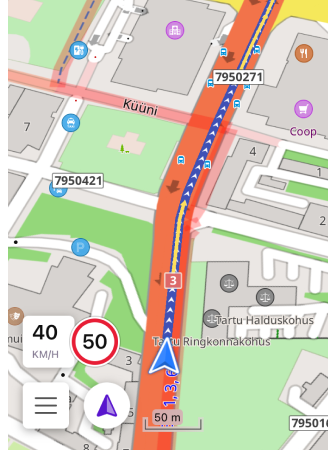
For this release, a new speedometer widget has been added. In the widget settings, you can choose from three speedometer sizes, set the speed limit tolerance, and enable warnings.
Speedometer for CarPlay

The Speedometer widget has also been added for CarPlay. The Speedometer widget is profile-dependent, so if you change the settings for one profile, they will not be applied to another.
Turn-by-Turn Instructions
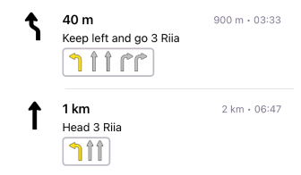
Turn-by-turn information provides detailed instructions for navigating your route. These instructions include information about your movements along the route.
Quick Actions Tool Update
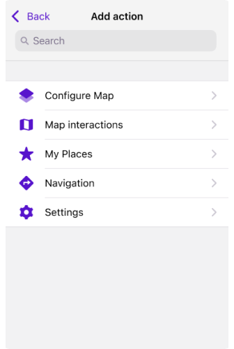
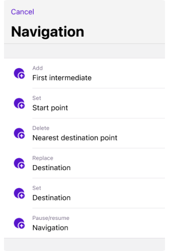
The updated Add Action screen makes it easier to customize and add Quick actions, improving access to important features. You can now find groups of actions, use the search function, and apply other actions to customize the Quick Actions tool, contributing to a better user experience.
Custom Buttons
Menu → Configure screen → Buttons → Custom buttons → + → Add button
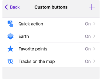
In this update, we have introduced Custom buttons in Configure screen, a unique type of Quick action tool. Now users can create custom action buttons for their device screen.
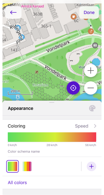
3D Track Improvements
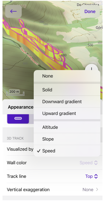
We have improved the appearance of the 3D track and added more options for wall colors. Now you can customize wall colors based on Altitude, Slope, Speed, Heart Rate, Bicycle Cadence, Bicycle Power, or Temperature.
Multiselect Mode for Tracks
Menu → My Places → Tracks → … → Select
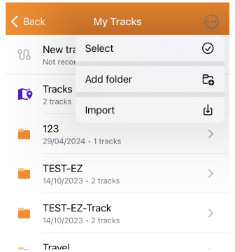
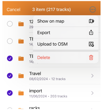
This menu item allows you to select the folders and routes required for further management.
3D My location Icons

A new 3D view has been added for My Location icons, which improves their visualization on the map. These changes bring the appearance of the icons in alignment with the 3D tilt of the map.
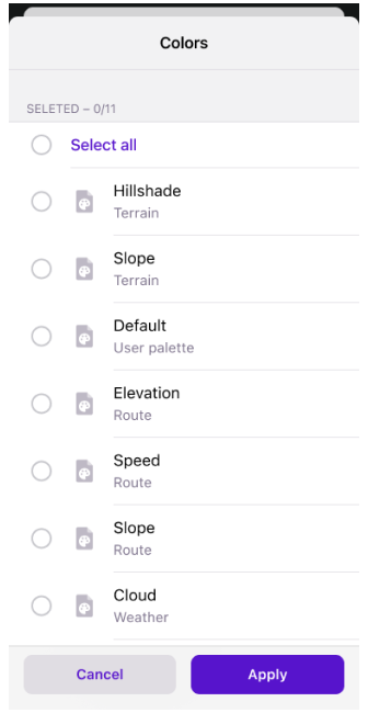
Color Palettes
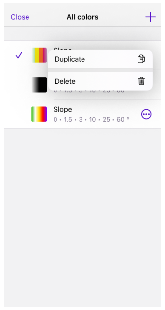
In this release, new color palette schemes have been added.
- For routes: Speed, Slope, and Elevation (Altitude).
- For terrain: Hillshade, Slope, and Altitude.
- For weather: All weather layers.
You can add your own color palette files to OsmAnd using the import/export tool. To do this, create a TXT file with the required name:
- Routes:
route_speed_name.txt,route_slope_default.txt,route_elevation_default.txt. - Terrain:
height_altitude_name.txt,hillshade_color_name.txt,slope_name.txt. - Weather:
weather_name.txt.
For example:
TXT file named *height_altitude_0-200.txt*

# 0 - 90 degree RGBA
0,46,185,0,191
# yellow
100,255,222,2,227
# red
200,255,1,1,255
# violet
220,130,1,255,255
After moving this TXT file to ..Android/data/net.osmand/files/color-palete/height_altitude_0-200.txt, a new palette will appear in the Color Scheme menu.
Color palettes data is available in the Maps & Resources menu.
Menu → Maps & Resources → Local → Colors
Weather Tool Improvements
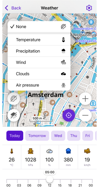
Layer animations and improved labels make the weather interface more visual and informative. These changes help you better understand current weather conditions and forecasts. Improved label visibility makes navigating weather data much easier.
Improvements:
- New weather panel with an updated user interface.
- Weather animation.
- After making sure the weather layers are selected, tap the Play button on the Weather screen.
- A Wind animation layer has been added.
Smooth Transitions
Smooth transitions have been added for the map when it is zoomed in 3D mode.
Location Position on the Screen
Menu → Configure screen → Other → Location position on screen
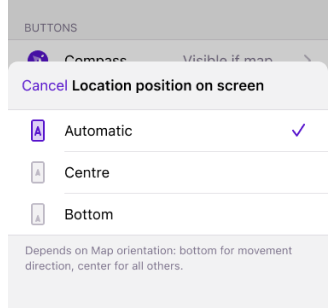
The Location position on screen setting has been moved to the Configure Screen menu.
Road Side Indicator
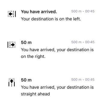
Added Road side indicator for Route Details.
The angle between the Destination (Bearing from the last point) and the last segment (Bearing to the last 2 points of the route) is measured and divided into 3 sectors of 120 degrees.
-60 °to+60 °= straight-180 °to-60 °= left60 °to180 °= right
Separate Speed Limit Alert

The Speed limit screen alert has been separated from the Traffic Warnings screen alert.
Login to OpenStreetMap
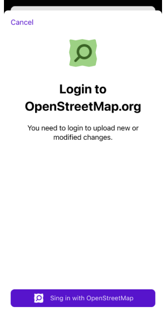
To improve security, the option to authorize with login and password has been removed. As of June 1, 2024, only the new secure OAuth 2.0 method will be supported. This authorization method provides a higher level of information security to help protect your data and prevent unauthorized access.
The Use username and password button has been removed from:
- Login to screen in the OSM Editing plugin menu.
- Benefits for active OSM contributors.
Optional Updates
Context menu for tracks in Configure map was added.
Added grouping of name-tag for Routes and POI's.
Added changing of "Wheel circumference" in BLE sensor settings.
Fixed:
Broken Hazmat parameters.
Bug with dublicates of Custom Plugins data.
Radius ruler visibility in all widget panels.
The Next Turn and Distance to Destination widgets.
Bad visibility of text on Next turn widget - CarPlay.
The crash while downloading in the background.
Favorite points sizes on Mac OS.