OpenStreetMap Editing
Overview
OpenStreetMap (OSM) is a global community that aims to create a detailed free geographical map of the world and provide up-to-date open-source data to every user. The OpenStreetMap editing plugin allows you to contribute to the community.
With OsmAnd and the OSM editing plugin, you can easily contribute your own information to OpenStreetMap.org, such as to create or modify POIs, add or comment notes, and upload recorded GPX tracks.
Required Setup Parameters
To use the OpenStreetMap editing plugin, you have to make the following settings:
- Enable Plugin.
- Set OpenStreetMap editing in any profile.
- Enable the display of OSM notes (online) or OSM edits on the map in the Configure map menu.
Settings
- Android
- iOS
- Menu → Plugins → OpenStreetMap editing → Settings
- Menu → Configure profile → Plugin settings → OpenStreetMap editing
- Menu → Plugins → OpenStreetMap editing
- Menu → Settings → App profiles → OpenStreetMap editing
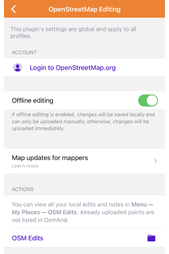
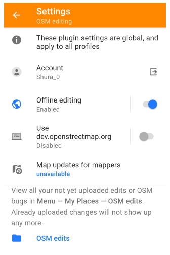
The plugin settings are global and apply to all profiles.
- Login to OpenStreetMap. Login to upload new or modified changes. Use the secure OAuth 2.0 method or log in on the OSM site. For iOS, the button for the OAuth method is available only for users with a supported version of iOS, 16.4
- Offline editing. If this setting is enabled, the changes are first saved locally (Save button) and uploaded on request. If the setting is disabled, the changes are uploaded immediately (Upload button).
- Use dev.openstreetmap.org (Android only). Allows you to enable dev.openstreetmap.org instead of openstreetmap.org to test uploading OSM Note, POI, or GPS tracks. When enabled, you are automatically logged out of OpenStreetMap.org. This setting is only available in the list when the OsmAnd development plugin is enabled.
- Map updates for mappers.
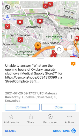
- OSM edits. Tap it to open Menu → My Places → OSM edits. This tab lists your unedited OSM notes. The following actions are available with the note: Upload, Show on map, Modify OSM note, Delete. Uploaded or deleted notes are no longer displayed in the list.
If you have an OsmAnd Pro subscription, changes made to OSM will appear on your OsmAnd map within one hour. Make sure that Live updates are enabled.
Authorization
- Android
- iOS
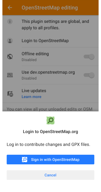
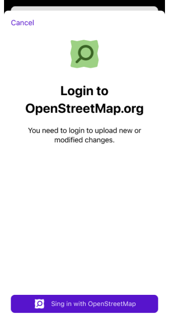
Login to contribute changes and GPX files.
- Go to openstreetmap.org and log in or sign up.
- Tap the Login to OpenStreetMap field in the OsmAnd app, then tap the Sign in with OpenStreetMap button.
Free map updates for mappers
- Android
- iOS
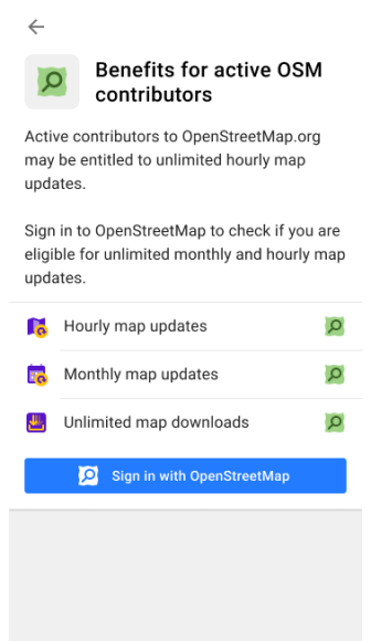
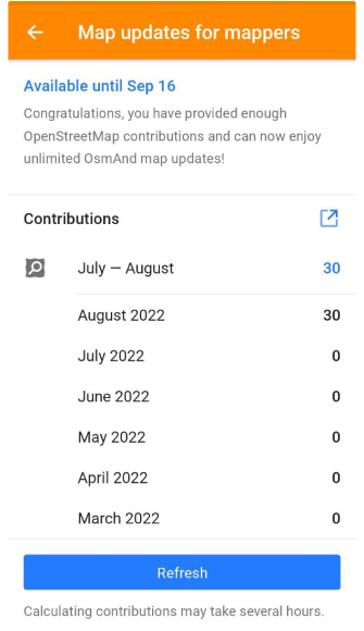
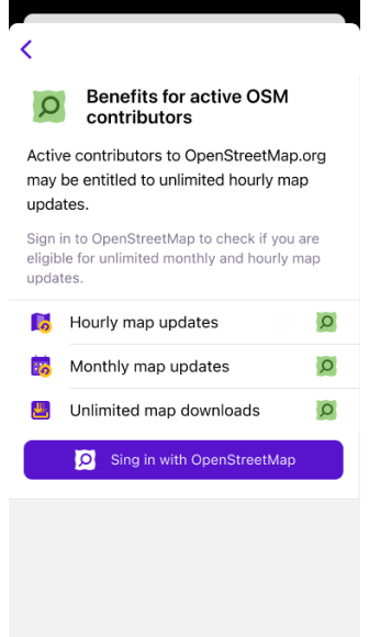
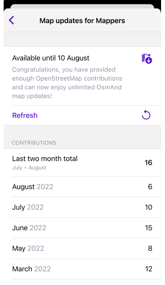
The Map updates for mappers setting allows you to enable live updates if you are active OpenStreetMap contributor. This way you can enjoy free hourly map updates, unlike the standard monthly updates. Active contributors to OpenStreetMap.org may be entitled to unlimited hourly map updates. Sign in to OpenStreetMap to check your eligibility for unlimited monthly and hourly map updates.
OSM Editing Layer
- Android
- iOS
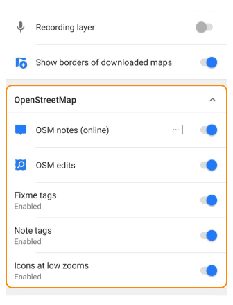
Go to: Menu → Configure map → OpenStreetMap
Go to: Menu → Configure map → OpenStreetMap
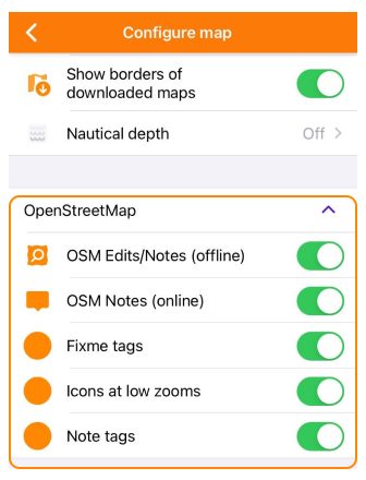
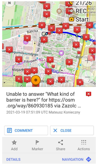
You can enable or disable as a separate layer the display of OSM modifications in the Configure map section of the Main Menu. OSM modifications include the following:
- OSM Notes (online). Displays public OpenStreetMap notes created by users to highlight mapping issues or request updates. Notes are shown as interactive markers that can be reviewed, opened, and resolved by mappers.

- OSM Edits. Shows your own local OSM edits stored on the device before uploading them to the OpenStreetMap server. This layer helps review geometry and attributes of objects you have modified or added.

- Fixme Tags. Highlights objects tagged with fixme=* in OSM. These elements contain mapper comments indicating that the information is incomplete, uncertain, or needs field verification.

- Note Tags. Displays objects that contain note=* tags — mapper comments embedded directly in the OSM data. These tags usually describe temporary conditions or additional context for future editing.

- Icons at Low Zooms. Enables simplified icon-like representations of OSM objects using short abbreviations derived from their primary tag keys. Their meaning is described here. This feature makes more objects visible at low zoom levels without overloading the map or causing icon overlap.

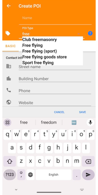
Create / Modify POI
The OpenStreetMap editing plugin allows you to create new objects on the map called points of interest or POI. You can map a new store, favorite landmark, bench, or shelter so people can find them.
- Tap the map to place a new POI, or tap a POI not yet loaded.2. Tap Actions.
- Choose Create POI, and add its name and other information such as hours of operation, website, etc. When you select a not uploaded POI, Create POI changes to Modify POI.
- Depending on the Offline editing setting, you can save the data locally or upload it.
Add tags
- Android
- iOS
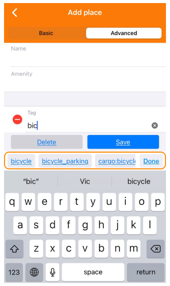
You can easily add OSM tags to the POI. When you enter several characters in the search bar, the program suggests possible tags.
Offline modifications.
You can view, upload to OSM, or delete POIs in My Places → OSM Edits. You can also export your OSM POIs changes to an OSC file and import it into JOSM.
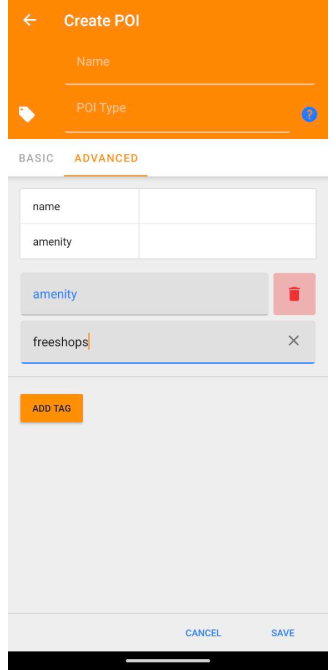
Add unsupported POI types
In the Advanced tab, you can add unsupported POI types that may be useful for your specific task. This option allows you to enter POI data manually thus extending the functionality of the application.
One example of unsupported POI types that you can add is amenity=freeshops. This type can be useful if you want to mark free stores or places that provide free products.
To add unsupported POI types, follow these steps:
- Open the Advanced tab.
- Tap the POI Type.
- Enter the amenity key and the freeshops value in the appropriate fields.
- Fill in the rest of the required data for this POI.
- Tap Add Tag to add the new POI to your database.
Remember that when adding unsupported POI types, it is important to make sure that the data is entered correctly to ensure the correct functioning of the application and subsequent processing of the information.
Create / Modify OSM Note
- Android
- iOS
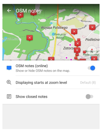
Go to: Menu → Configure map → OSM notes (online)
Go to: Menu → Configure map → OSM Notes (online)
To edit, comment, or close OSM notes, enable their display on the map in the Configure map menu.
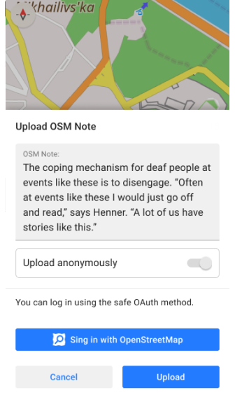
- The OSM Notes feature allows you to add notes to the map. In these notes, you can describe mistakes or write about missing information in the OpenStreetMap data. You and other users can leave comments on your notes.
- You can help other users by checking their questions or issues, giving comments, and then closing the resolved notes.
- Read more about the OpenStreetMap Notes here.
To create a note, you don't need to log in to OpenStreetMap.org, you can send it anonymously.
- Tap the map where the new OSM note is to be placed (or tap a not uploaded note), and select Actions.
- If you want to add information to an existing note or not uploaded note, edit a comment, or close a note, tap the OSM note on the map and select the required action.
- You can upload changes as soon as you are available online. You can also undo changes before they are uploaded.
The uploaded OSM Notes are not visible on OsmAnd maps in offline mode.
GPS Track
The GPS tracks you have recorded are useful for:
- Mappers. Tracks can be used to map all kinds of paths.
- Navigation. Based on the GPX file data you uploaded, navigation applications and special devices can calculate tracks.
- To share information about the tracks and routes you recorded on OpenStreetMap based maps.
Your tracks will be added to OSM traces within an hour where they will be available for you and others to view, search, and use.
Upload GPS track
- Android
- iOS
To upload the GPS track, follow the steps below:
- Find the required track in Menu → My Places → Tracks tab.
- Tap the three-dot menu next to the track name and select Export.
Settings:
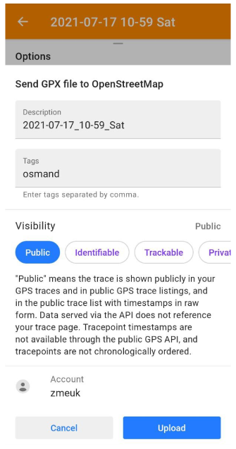
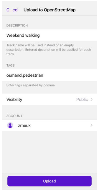
- Description. Allows you to add a description to the track. The description applies to all selected tracks. If you enter nothing in the field, the track names for each separate track are used as descriptions.
- Tags. This item in the settings section allows you to add tags to identify the track. The default tag is "osmand". If the track was recorded with a specific activity based on the selected profile, this activity is also automatically added as a tag during upload. For uploaded groups of tracks, each track receives its own activity tag. For some profiles (e.g. Public transport), the activity tag is not added. You can enter additional tags manually, separated by commas.
- Visibility. Track visibility for OSM users:
- Public means that the track is publicly available and displayed in raw form in your GPS tracks, GPS track lists, and timestamped track lists. The data transmitted through the API is not referenced with your track page. Trace point timestamps are unavailable through the public GPS API and track points are not ordered chronologically.
- Identifiable means that the track will be publicly displayed in your GPS track points and public GPS track lists, which means other users will be able to download the raw track and associate it with your username. Public timestamped track points data from the GPS API passed through the track points API will link to your original track page.
- Traceable means that the track is not displayed in public lists, but the processed track points with timestamps from it (which cannot be linked to you directly) are loaded from the public GPS API.
- Private means that the track is not displayed in public lists, but the track points from it in non-chronological order are available through the public GPS API without timestamps.
- Account - OSM account.
You can select more than one track to upload to OSM. To do this, tap the Upload to OpenStreetMap icon at the bottom of the screen, select tracks using the checkbox, tap Upload, and then Continue.
Generate OBF file
You can create an OBF file with OsmAndMapCreator if you have a large GPX track database. This is a collection of tracks from osmand.net with the 'gpsies' tag, a collection of downloaded tracks from OpenStreetMap or your own collection.