
OsmAnd Heatmap: explore millions of real GPS tracks
OsmAnd Heatmap is a new web tool that shows where people actually move — on foot, by bike, by car and more. It is built from the public GPS traces of OpenStreetMap: every track that OSM contributors have uploaded is counted per map cell, by activity and by upload month, and drawn as a heatmap. The brighter the line, the more tracks pass through that spot.
It is built entirely on open data — and it lets you look at every single track behind the picture.
The tool is currently in test: test.osmand.net/map/prototypes/heatmap.html
At the end of this article you'll find a short survey. Your feedback shapes what comes next.
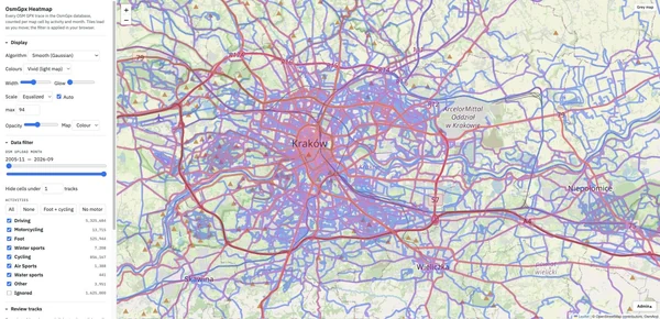
More than 8.3 million OSM GPX traces are indexed. About 6.7 million of them are shown by default; the rest are very short, sparse or unreadable tracks that are hidden unless you switch the Ignored group on. Tracks are grouped by activity: driving, cycling (road, MTB, gravel, e-bike…), foot (hiking, running, walking…), motorcycling, winter sports, water sports, air sports and others.
The interface
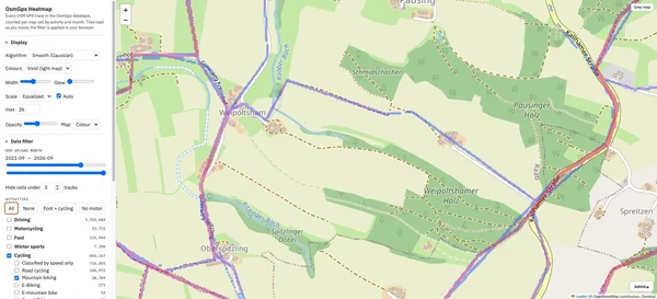
The map fills the screen, the left panel holds four sections. Tiles are loaded once; all filters below are applied instantly in your browser.
Display
How the heatmap looks.
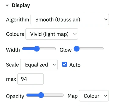
- Algorithm — Smooth (Gaussian) draws soft ribbons, Sharp thin lines keeps lines crisp at low zoom, Raw cells shows the underlying grid.
- Colours — four palettes: Vivid for the light map, Turbo, Hot and Blue for the dark map.
- Width and Glow of the lines.
- Scale — Equalized spreads colours evenly over the tracks in view (so 1, 2 and 3 tracks get distinct colours), Log is a classic logarithmic scale. Keep Auto on and the scale adapts to the visible area; switch it off and set your own max.
- Opacity of the heat layer and the Map style underneath: Grey, Dark or Colour.
Data filter
Which tracks are counted.
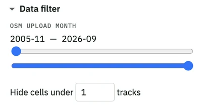
- OSM upload month — two sliders limit the date range: only tracks uploaded to OpenStreetMap in that period are drawn. The full range starts in 2005.
- Hide cells under N tracks — the minimum number of tracks needed to draw a line. With 1 every single track is visible; set 5 and only places where at least five tracks overlap are shown — the popular routes stand out, the noise disappears.
Activities
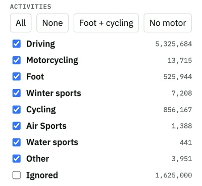
Every activity group has a checkbox and a track count. Expand a group to pick single activities — for example only Mountain biking inside Cycling. The quick buttons All, None, Foot + cycling and No motor switch typical sets in one click. The Ignored group (short, sparse, unreadable or untimed tracks) is off by default.
Review tracks
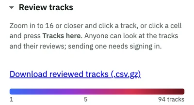
To leave a review, sign in first with your OsmAnd account at test.osmand.net/map/account — then come back to the heatmap. Viewing tracks does not require an account.
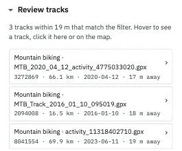
The heatmap is not only a picture — you can get to the tracks behind it. Zoom in to 16 or closer and click a line on the map: the panel lists the tracks that pass under your click. Pick one to see it on the map with its details, download the original GPX file, or leave a review. Anyone can look at the tracks and their reviews. The link Download reviewed tracks (.csv.gz) at the bottom of the section exports all tracks that have been reviewed so far, with their verdicts, as one CSV file.
Data source
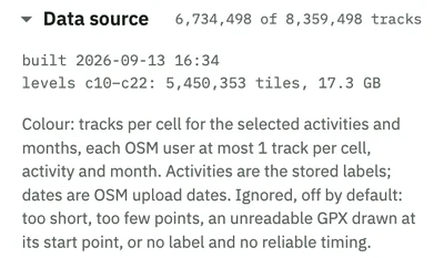
How many tracks match the current filter, when the data was built and how the colours are computed. Each OSM user is counted at most once per cell, activity and month, so one very active uploader cannot paint a whole region.
Example: mountain-bike trails in Upper Austria
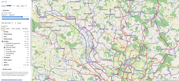
Let's find the MTB routes around Kallham, Austria (48.38° N, 13.60° E) that people rode in the last five years.
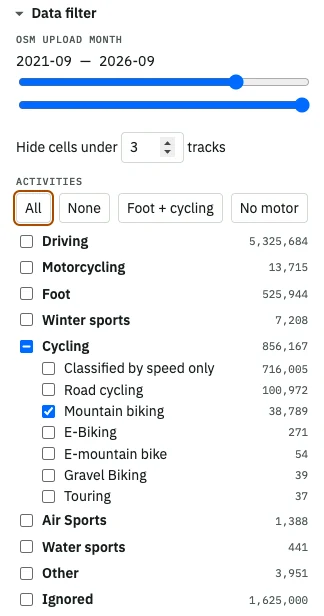
1. Choose the activity. Press None, expand Cycling and tick Mountain biking.
2. Set the period. Move the left date slider to 2021-09 — older tracks are not needed.
3. Set the density. Put 3 into Hide cells under … tracks: only trails ridden by at least three people remain.
The map now shows the network of trails that mountain bikers really use:
4. Zoom in and click a trail. Open this spot at zoom 16 and click one of the lines.
The Review tracks section lists the tracks under the click, each with its activity, file name, length, date and distance from the point:
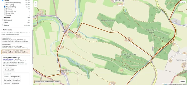
5. Select a track. Click an item in the list (or the line on the map): the track is highlighted on the map and its card opens — a link to the OSM trace, activity, length, date, tags and description. Download GPX gives you the original file from OpenStreetMap with time and elevation.
6. Leave a review. Choose a verdict — Correct, Wrong activity, Bad quality, Wrong line, Simulated or Not a track — optionally pick the correct activity and add a comment, then press Send review.
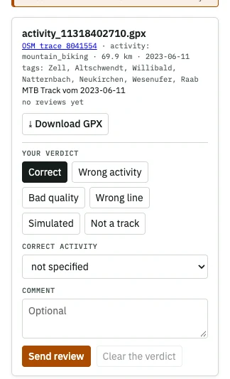 | 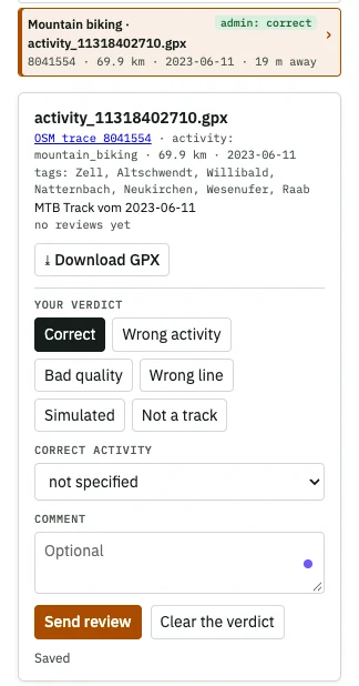 |
Your verdict is saved and shown next to the track in the list. Reviews help us improve the activity classification and clean the data.
Reviews are tied to your OsmAnd Cloud account. Before sending one, activate your account on the test server at test.osmand.net/map/account — sign in with the same e-mail you use for OsmAnd Cloud in the app — then return to the heatmap. Viewing tracks and reviews does not require an account.
Tips
- The URL keeps the map position (
#zoom/lat/lon), so you can share a link to any place. - Display settings are remembered in your browser; filters reset when you reload the page.
- Use the Dark map with the Hot or Blue palette for the classic heatmap look.
- On a busy street thousands of tracks may overlap; the track list shows the 60 nearest to your click.
Tell us what you think
The heatmap is a prototype, and your feedback decides where it goes next.
- 2-minute survey — how you use it and what is missing: Heatmap feedback form
- Rate the tracks — zoom in, click a trail you know and send a verdict. It takes a few seconds and directly improves the data (sign in with your OsmAnd Cloud account on test.osmand.net/map/account first).
Follow OsmAnd on Facebook, TikTok, X (Twitter), Reddit, and Instagram!
Join us at our groups of Telegram (OsmAnd News channel), (EN), (IT), (FR), (DE), (UA), (ES), (BR-PT), (PL), (AR), (TR).