Maps & Resources
Overview
In the Maps and Resources section, you can manage Online and Offline maps, and other resources used in OsmAnd. For example, you can download, delete, rename, clear cache, update and check size, and perform different actions.
OsmAnd operates with two types of maps: Vector maps and Raster maps. The Local tab stores all maps and resources. Available map types can be downloaded from the Downloads tab. On the Updates tab, you can download maps that are available for updates and use Live updates. You can also access the Extra map feature to create your map types.
- Android
- iOS
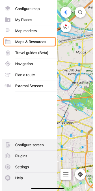
Go to: Android Menu → Maps & Resources

Go to: iOS Menu → Maps & Resources
Map Types
- Android
- iOS
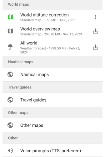
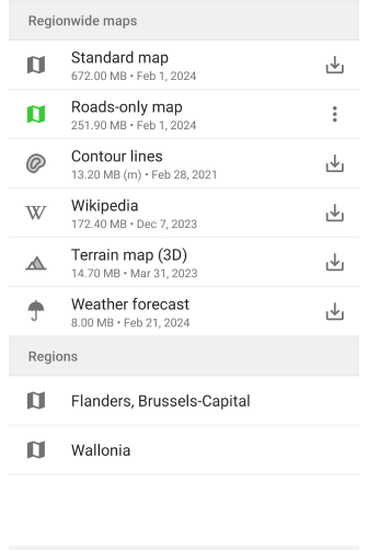
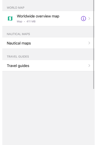
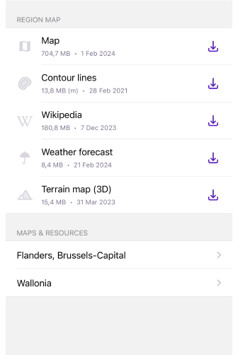
Downloading maps into the OsmAnd application is an important step that determines the functionality and efficiency of navigation.
Free Features for the Selected Location
- Standard map. Provides an overview of the area based on the OpenStreetMap source and contains a map, routes, addresses, POI, and public transportation information. Tapping opens a screen with a list of regions of the selected country and information about how much space these maps will take up on your device.
- Roads-only (Android only). The map contains only road grid information to focus on routes and road infrastructure. By removing details such as buildings and points of interest, it is smaller than a standard map. Tapping opens a screen with a list of regions in the selected country and information about how much space these maps will take up on your device.
Paid Features for the Selected Location
- Contour lines. A map containing contour elevation lines to visualize the terrain.
- Terrain map (Hillshade and Slope). Maps with shadows or slopes provide additional terrain information.
- Terrain map (3D). Three-dimensional representation of the terrain for a better understanding of your surroundings. Map rendering engine Version 2 (OpenGL) must be enabled.
- Wikipedia. Vector map with geo-positioned Wikipedia articles about landmarks or additional information about places.
- Weather forecast. Weather information on a map for easy route planning.
- Online raster maps. The maps are available for download online and can be installed as third-party maps or OsmAnd Tiles.
World Overview Map
Versions of OsmAnd up to 3.8 offer to download a world map so you can view it on a planetary scale. In newer versions of OsmAnd, a lightweight Mini World Map is bundled with the application. The app lets you download a larger overview world map with more detailed information.
Maps & Resources
The Maps & Resources Main Menu section of the OsmAnd app provides access to manage maps and other important data.
- The Download maps tab allows you to download maps for offline use, ensuring their availability without the internet.
- In the Local maps tab, you can find and manage detailed information about maps and places, including favorites, tracks, OSM notes, and other items you have on your device.
- The Updates tab allows users to get information about available updates to maps and other resources, ensuring that the data is up-to-date and accurate.
General actions you can do in Maps & Resources:
- Refresh. Reloads the list of available maps from the OsmAnd server.
- Search. Search for maps by country, province, or major city.
- Device memory. Shows on the indicator how much memory is available for download and how many maps can be downloaded for free. Depending on the tab, sometimes slightly different data is displayed.
- Map counter (Free version is only visible if you don't have a subscription). The indicator with dividers shows how many maps you have left to download out of the 7 available.
Please note that monthly map updates are considered another map download and are substracted from the available number of free map downloads.
Downloads
- Android
- iOS
Go to: Android Menu → Maps & Resources → Downloads
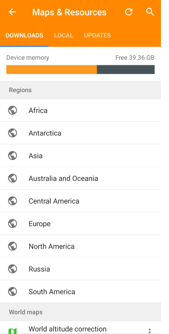
Go to: iOS Menu → Maps & Resources
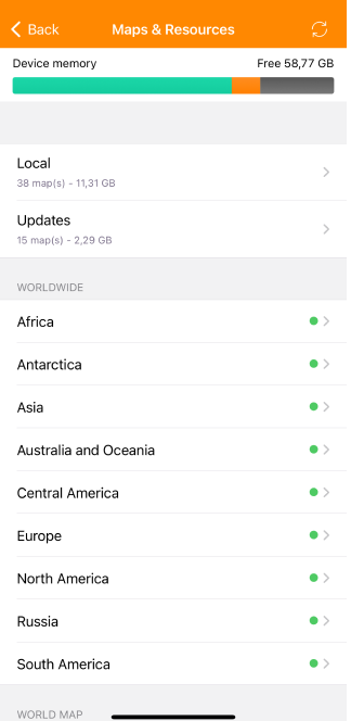
The Download tab lets you download various map types from OsmAnd servers, requiring an active Internet connection.
To download a map:
Open the Download tab, locate the required section, and tap the relevant folder to see available maps.
Available maps display download icons, for a single map or for multiple maps.
Downloaded maps show a green icon with a menu button:
- Android: Three-dot menu.
- iOS: Info (I) icon.
Maps in the process of loading have an icon visualizing this. To cancel the download, tap the icon. To view the list of maps in the download queue and cancel the downloads, tap the Download bar in the Device memory info area of the Downloads and Updates tabs.
In the Free version, maps unavailable for download show a GET icon, linking to the purchase page.
The downloads tab consists of map groups:
- Device memory info. Visualize the amount of occupied and free space on your device.
- Map counter (Free version). Displays how many maps you have left for download.
- Extra maps. Displays the map data for the Custom package.
- Regions. List by continent and world region: Africa, Antarctica, Asia, Australia and Oceania, Central America, Europe, North America, Russia, and South America.
- World maps. A list of maps of the entire world: World altitude correction (Android only), World overview map, All world (Weather forecast)
- Nautical maps (paid feature). Vector maps with elevations as points or lines.
- Travel guides (Wikivoyage) (paid feature). Vector maps with a collection of articles in HTML format and additionally GPX files.
- Other maps. Maps that cannot be assigned to the current map hierarchy because they are not supported or will be available in future versions.
- Voice prompts (Android only). Voice packs for voicing navigation prompts.
- Map fonts (Android only). Additional font files display text on the map.
World Maps
In the Download Maps menu, there is a World Maps section that provides access to download various maps of the world, complementing the functionality of the app.
- World Altitude Correction (Android only). Improves navigation accuracy, especially in mountainous terrain.
- World overview map. Provides an extensive overview of the earth's surface, useful for long-term route planning and casual exploration.
- All world (Weather forecast). Allows you to download a map with weather information.
Information about maps menu and actions can be found in the article Download maps.
Multiple Map Loading
- Android
- iOS
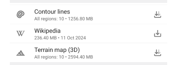
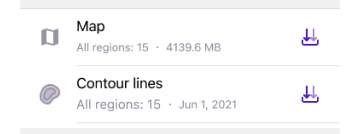
For countries consisting of multiple region maps, you can use bulk loading of multiple maps. Maps available for this type of download are displayed with a double download arrow icons and a label with the number of regions inside (e.g. Contour lines / All Regions: 10). You get to choose how many maps to download.
Local
- Android
- iOS
Go to: Android Menu → Maps & Resources → Local
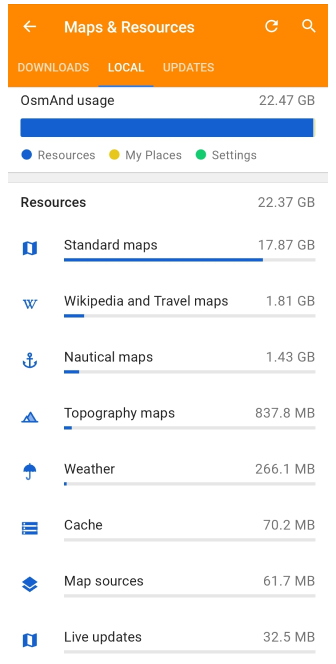
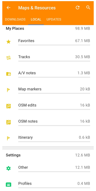
Go to: iOS Menu → Maps & Resources → Local
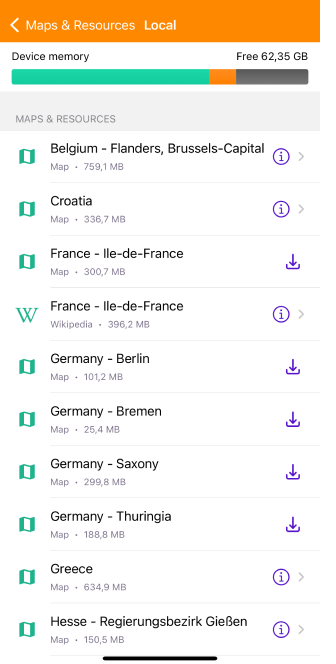
The Local tab provides an overview of the storage usage for all OsmAnd data on your device. Data is divided into three color-coded sections for clarity, with items sorted by size from largest to smallest. Each section displays only items with downloaded data:
Resources (blue).
Includes maps (Standard, Nautical, Topography, Weather), Wikipedia and Travel guides, Live updates, Road only, Map sources, Rendering styles, Map fonts, Voice prompts (recorded and TTS), Cache.My Places (yellow).
Includes Favorites, Tracks, OSM Notes, OSM Edits, A/V Notes, Map markers, History, Itinerary.Settings (green).
Includes Profiles, Colors and Other app configurations.
Viewing Data
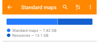
Tap any item in the Local tab to open its detailed list. At the top of this list, a visual panel displays how much space the selected data type occupies relative to the total OsmAnd storage.
Available actions:
- Search. Find specific data by name within the selected folder.
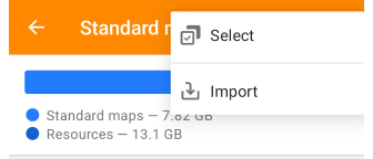
- Three-dot menu:
Select. Choose multiple items for actions like Delete, Deactivate, or Activate.
Import. Access the device's storage to import files. - Sorting option. Sort items by name, country, date, or size (availability depends on the data type).
Menu for Items from the List
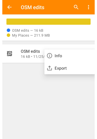
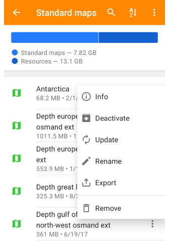
Each item in the list offers a three-dot menu with options:
- Info. View detailed information on the data item.
- Export. Save data to a file via Settings → Export to File.
Additional options for maps:
- Deactivate. Disable vector maps without deleting them. They remain stored but are not used for navigation, search, or routing. Reduces the load on the device and speeds up OsmAnd.
- Update. Download the latest version of the map.
- Rename. Customize the map’s name for better identification.
- Remove. Delete the map from your device.
- Edit (for Online Maps). Modify the online map configuration.
Map source items menu
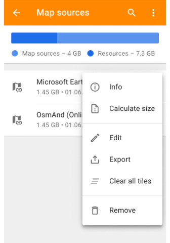
Each item in the Map source list provides settings for managing online raster map stored on your device. Open the three-dot menu to access the available actions:
- Info. Displays general details about the selected map source, including format and last update date.
- Calculate Size. Estimates the storage occupied by the cached tiles of this map source. If the cache exceeds 50MB, the size can be displayed as ≥50MB instead of an exact number.
- Clear All Tiles. Deletes all cached tiles for the selected map source, freeing up storage while keeping the map source available for future use.
- Export. Saves the selected map source configuration for backup or sharing.
- Remove. Deletes the selected map source. This action does not affect downloaded offline maps but clears the associated cache.
Local Data Item Overview
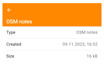
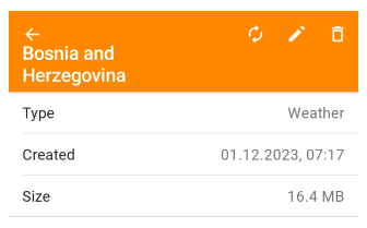
When viewing a local data item, you see:
- Type. The data type from the Local list.
- Created. The date the item was added.
- Size. The item’s size is in MB.
Available Actions depend on the data type and may include Deactivate, Update, Rename, Export, and Delete.
Sorting Options
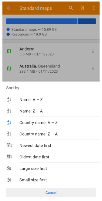
Use sorting options to organize map data:
- Name (A - Z / Z - A). Locate items alphabetically.
- Country name (A - Z / Z - A). Organize maps geographically.
- Newest date first / Oldest date first. See updates or older versions.
- Large size first / Small size first. Identify large maps to free storage space.
Updates
- Android
- iOS
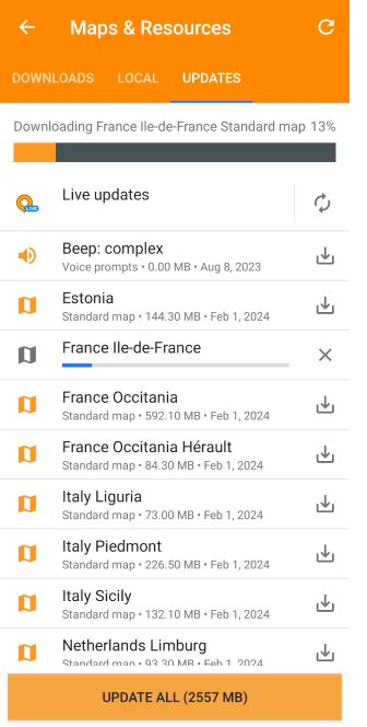
Go to: Android Menu → Maps & Resources → Updates
Go to: iOS Menu → Maps & Resources → Updates
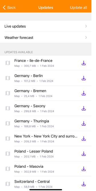
The Updates tab allows you to refresh OsmAnd maps monthly. Use the Update all button to update all maps simultaneously, or update individual maps as needed. Standard and road-only maps are typically released two weeks into each month. For hourly updates, check your OsmAnd Live subscription status. If enabled, the Live Updates section will appear at the top of the tab, under the Device Memory indicator.
Extra Maps
OsmAnd supports the transfer of profile-specific settings and data, including rendering files, fonts, routes, maps, and custom plugins. Create a custom map folder using a .osf plugin file (a compressed .zip format).
To import a file:
- Locate the
.osffile in your device’s storage, messenger, or email. - Tap to open it with OsmAnd.
- The plugin will appear in the Plugin List section, where it can be activated.
- A corresponding folder will then appear in the Extra Maps section of the Downloads tab.
Read more in the Custom package article.
OsmAnd Live
OsmAnd Live is a paid feature.
- Android
- iOS
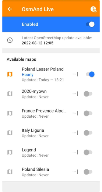
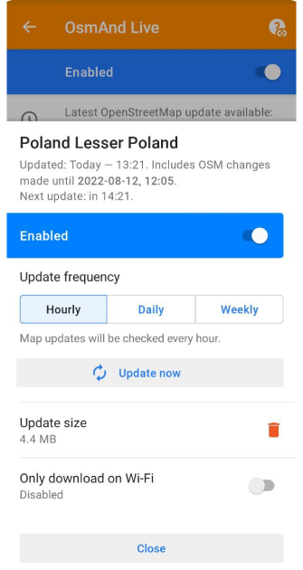
Go to: Android Menu → Maps & Resources → Updates → Live updates
Go to: iOS Menu → Maps & Resources → Updates → Live updates
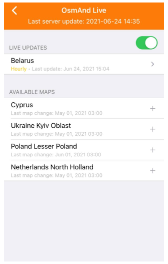
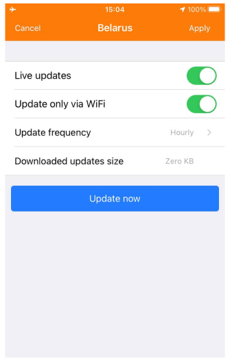
OsmAnd Live provides frequent, incremental map updates through subscription or is free for OSM contributors. Updates occur every 15 minutes on OsmAnd servers and are downloadable hourly, daily, or weekly. These updates consume minimal storage — about 2-4% of the full map size per month.
Key features:
- Enabled / Disabled Live Updates. Manage via a toggle in the settings.
- … | button (Android) / > button (iOS). Open OsmAnd live settings.
- Switcher(Android) / + button (iOS). Add maps for live updates.
- Update frequency. Select the map update frequency (hourly, daily, or weekly).
- Update now. Start the OsmAnd live map update.
- Update size(Android) / Downloaded updates size(iOS). Size of live updates.
- Trash button(Android). Delete all received live updates for the current map.
- Only download on Wi-Fi. Manage the download of live updates over a Wi-Fi connection.
Update Timestamps
- Latest OSM update.
Indicates the last processed OpenStreetMap changes. - Region Updated.
Shows when the specific region’s updates were last processed. - Next update.
Displays the scheduled time for the next update check.
Limitations of OsmAnd Live
Address changes are supported only via monthly updates. Updated roads lack elevation details, affecting gradient graphs. Deleted or altered route references may still appear incorrectly.
Free for OSM Mappers
- Android
- iOS
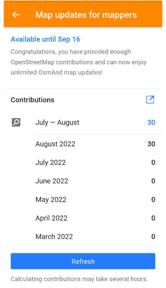
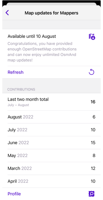
Contributors to OpenStreetMap are eligible for free unlimited map downloads and live updates. To qualify: Enable the OpenStreetMap Editing plugin. Log in with your OSM username. Maintain at least 30 edits over the last two months.
Related Articles
Common Issues and Solutions
- Voice Navigation. (check)
- How to delete search history. (check)
- For additional troubleshooting, visit: Maps & Data
This article was last updated in February 2025